| WGS84 | |
| 35.528600 | -83.977400 |
| 35° 31.716'N | 83° 58.644'W |
| 35° 31' 43"N | 83° 58' 38.6"W |
| 17S 230026E 3935744N | |
| convert to NAD27 | |
MAPS
Select one of the following maps to display this waypoint (WGS84).
GPS
Remarks:
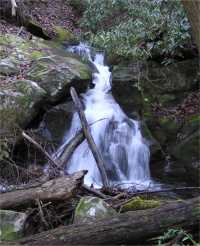
wet-weather falls. off-trail.
1931 topo shows old road bed along Shop Creek. About a half mile upstream of the falls is the naked Lady of Shop Creek
 AT shelters
BSF landforms (TN/KY)
AT shelters
BSF landforms (TN/KY)